Inland waterways in India- challenges and future
12 Oct 2022 15:10:49
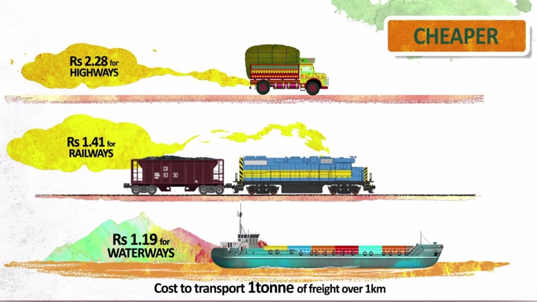
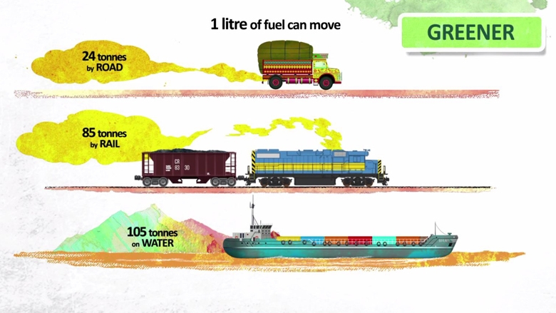
Rivers have served as effective waterways throughout history, carrying people and goods long distances. Archaeologists have found a burnt brick basin at Lothal, Gujarat India built during the Indus Valley Civilization in about2400BC. Kautilya (4thCentury BC) in his Arthashastra wrote extensively about navigation, boat sizes, port charges, ferry regulation laws, expeditions, the duties of the state and the workforce, and trade and taxation in the days of the Mauryan Empire. It is still cheaper, more reliable, and less polluting to transport goods by inland water, especially for large and bulky cargoes than by road or rail.

India's development of a cheaper, greener mode of transportation means goods can now travel without the stress of a congested road or rail network. This type of shipping is noticeably faster than any other, and it decreases uncertainties when it comes to trade. As per the World Bank logistics costs, India is estimated to account for as much as 18% of the country's GDP.
The Ganga river was once a busy waterway, but when railways came about around 1836, it fell into disuse. Now, India is working to revive the Ganga. It's called National Waterway1 and will run just over 1,360 km on the water to carry cargo from Haldia Bay to Varanasi.

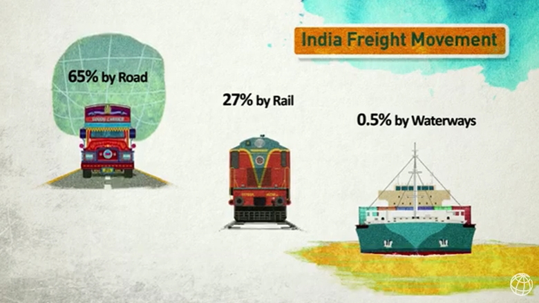
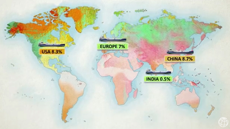
In India, one of the most densely populated areas can be found between Delhi and Kolkata. This region, with miles of riverfront, is all about trade. A sizeable forty percent of Indian goods that are either being traded or traded from this region originate from here. However, a World Bank report says only 5 million metric tons—just 2%—of India’s freight travels by water.
Currently, cargo from the Gangetic states of Uttar Pradesh and Bihar has to take a long land route to reach the Mumbai port in Maharashtra or the Kandla port in Gujarat. The NW1 project will help shorten this trip, making freight movements more reliable and lowering costs.
With a loan of $375 million, The World Bank is financing the development of the Ganga waterway. This project intends to provide infrastructure and services for infrastructure and Services for NW1, which will then become an efficient economic artery in this important region.
Once operational, the river will become part of a larger multi-modal transport network as a part of the at shakti initiative, that Hon. Prime Minister Narendra Modi is driving. The waterway will link up with the Eastern Dedicated Rail Freight Corridor and with other existing highways in the region. This web of water, road, and rail arteries will help people's industries switch between different modes of transport to send their goods to markets in India and abroad. It will also help farmers in the agriculturally-rich Gangetic plain who want to access markets further away.
Setting up the Navigation
One of the reasons for the slow development of water transport has been a lack of essential infrastructures such as cargo terminals and jetties. With this in mind, the National Waterway 1 Project will set up six multi-modal freight terminals - at Varanasi, Ghazipur, Kalughat, Sahibgunj, Triveni, and Haldia. In addition to these stations at new crossings at different locations, the six terminals will have the ability to evolve into thriving logistics hubs with thousands of jobs throughout one of the poorest and most populous parts of India. The Project will also establish a vessel repair and maintenance facility in Doriganj.
The project will not only upgrade the existing lock but also build a new one, allowing two-way traffic. These improvements will help to reduce the time needed to cross the lock.

The Project will help set up a state-of-the-art river Information System (RIS), which will help make navigation both safe and efficient. As a barge operator or cargo owner, being able to track your vessel's location and successfully plan accordingly can be immensely beneficial. Furthermore, the RIS will enable you to find berths in terminals in advance so as to better plan logistics. To keep navigation safe both day and night, the Project will outline the central channel for boats to play in along with installing specialty night navigation facilities. Plus, detailed protocols are being laid down for dealing with emergencies, including for tackling the spillage of oil from boats.
"We work with Nature"
India's Ganga river occupies a special place within the social, cultural, and environmental landscape. To take advantage of it, the Inland Waterways Authority of India (IWAI) has sought to adopt the least intrusive methods of making the Ganga navigable. It has followed the principle of ‘working with nature, and as a result, we're doing as little as possible to change the natural environment.

Unlike many major rivers, the Ganga is a seasonal river that swells with rain and recedes when it's winter. Because of this, small boats can travel on the river in the dry season; however, large cargo barges need a minimum depth of2.5 meters to sail in. Therefore, shipping on the Ganga has been largely limited to the downstream stretch between Farakka and Haldia because this area boasts sufficient depth - usually not less than 3 meters deep - for vessels to sail through all year.
For centuries people have navigated the Ganga by boat. This requires a significant amount of dredging since it's naturally shallow and does not come into contact with the bottom that often. But in the case of the Ganga, special care has been taken to maintain the depth needed for larger boats, even those that carry up to 2,000 tons of cargo.
A channel 45 meters wide has been marked in the deepest part of the river, and the Least Available Depths (LAD) necessary for navigation are based on the need to reduce dredging. The depth of the channel varies along with the natural gradient of the river and is sufficient for two-way movement by large barges.
These measures will reduce the need for dredging to just 1.5 percent of the river's annual silt load, or about 10-11 million cubic meters per year. Even this limited dredging will only be done when absolutely necessary and will happen with advanced technologies. Among these technologies is the proposed water injection method that uses high pressures to break up deposits and wash them away as a dense slurry, which is then deposited - either naturally or through induced currents - in depressions along the riverbed, ensuring that sediments remain within the river’s ecosystem.
When necessary, temporary bamboo structures will be set up in aquatic habitats to channel the water flow. These structures – or bands – will most often be placed near sanctuaries to help protect the diverse wildlife there.
Protecting the aquatic environment
IWAI is creating sustainable solutions for boatmen, like the Rewri Jetty in Varanasi and the Ghildayakadhan at Bhagalpur. These facilities will improve the livelihoods of boatmen and make sure that water traffic does not impact the two aquatic wildlife sanctuaries that fall along this stretch of the river.
First, we will feed data about these protected aquatic habitats and other sensitive areas such as wetlands into the new River Information System being built. This will ensure vessels plying in these zones comply with the operational framework put into place to minimize negative impacts on these areas. This framework includes:
· Banning dredging in protected habitat areas
· In areas where aquatic species are known to breed and spawn, dredging will not be allowed for part of the year.
· The top speed of vessels traveling in sanctuaries will be limited to 5 kilometers per hour.
· All boats will have noise control and animal exclusion devices to make sure the aquatic life is left unbothered.
· The law ensures that all vessels will have a low discharge level. The goal is to prevent any solid or liquid waste from the vessels from flowing into the river and affecting its biodiversity.